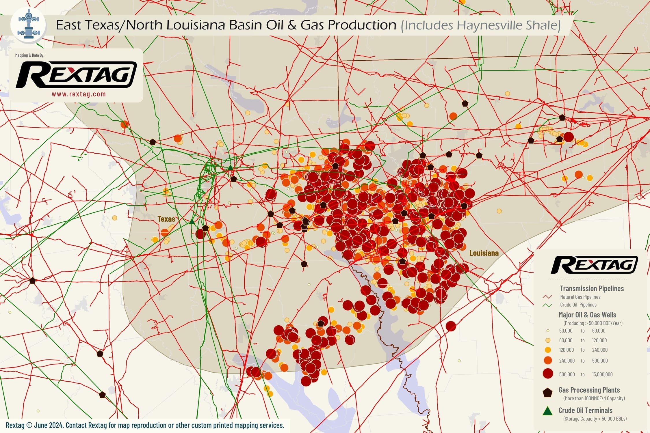
East Texas / Louisiana (Includes Haynesville Shale) - Upstream Oil & Gas

Description

The Haynesville Shale, which spans across East Texas and Louisiana, is known for its significant depth and natural gas production capabilities. This geological formation is typically found at depths ranging from 10,000 feet (about 3,000 meters) to 13,000 feet (about 4,000 meters). The formation gets deeper as it extends southward toward the Gulf of Mexico?. At the start of 2023, the daily production was 463,000 BOE per day and reached an impressive 1,270,000 BOE per day as of December 2023.

upstream oil and gas
Production Summaries
Monthly Production
Presented Data in the chart below is delayed - LOGIN FOR UPTODATE
Production by Operator
Production by Formation
Production by County
Top 10 wells
API Operator Trailing 12 Months BOE Total BOE Total Gas (MCF) Total Oil (BBL)
17-015-24728-0000 Comstock Oil & Gas Louisiana, LLC 4,986,807.00 6,773,055.00 40,638,330.00 0.00
17-015-24732-0000 Comstock Oil & Gas Louisiana, LLC 3,216,928.67 4,532,030.33 27,192,182.00 0.00
17-015-25275-0000 BPX Operating Company 2,260,078.53 2,667,378.52 16,004,271.09 0.00
17-015-25276-0000 BPX Operating Company 2,668,979.20 3,166,813.72 19,000,882.34 0.00
17-017-36427-0000 BPX Operating Company 2,038,043.81 7,734,469.71 46,406,818.28 0.00
17-017-36657-0000 BPX Operating Company 2,253,524.32 2,683,425.89 16,100,555.33 0.00
17-017-36658-0000 BPX Operating Company 2,224,285.49 2,652,266.43 15,913,598.58 0.00
17-081-21649-0000 Chesapeake Operating, Inc. 2,067,659.43 2,921,945.96 17,531,675.76 0.00
17-081-21734-0000 BPX Operating Company 2,639,515.17 5,151,844.17 30,911,065.01 0.00
17-081-21781-0000 Chesapeake Operating, Inc. 2,602,580.75 3,133,892.04 18,803,352.23 0.00
Completion Summaries
Avg Depths

Wells Depth

Min
0
Max
25,202
Avg
4,773

Wells Vertical Depth

Min
0
Max
21,026
Avg
1,557

Wells Lateral Length

Min
0
Max
15,726
Avg
731

Wells Measured Depth

Min
0
Max
30,937
Avg
3,579
Well Counts by Categories

Wells By Formation

Formation
Well Count
Cotton Valley
13,374
Nacatoch
11,655
Monroe Gas Rock
5,141
Travis Peak
4,910
Haynesville
2,976
Haynesville Shale
2,358
Mon Gr
1,863
Chalk
1,589
Lower Cotton Valley
864
Cotton Valley Sand
864

Wells By Status

Status
Well Count
Inactive, P/A
101,891
Active
43,755
Shut-in
18,267
Unknown
12,996
Cancelled
8,783
Permitted
477
Orphan
324
Drilling
36

Wells By Trajectory

Trajectory
Well Count
Unknown
119,168
Vertical
54,117
Horizontal
11,102
Directional
2,359

Wells By Operator

Operator
Well Count
ExxonMobil
7,005
Basa Resources
3,852
Harvest O&G
3,296
Expand Energy
2,930
Aethon
2,426
Three Sisters
2,093
Diversified Production
2,068
Comstock
2,030
Spicy Daugx Operators Louisiana
1,646
TGNR East Texas
1,315
Well Completions
Presented Data in the chart below is delayed - LOGIN FOR UPTODATE
Well Permits
Presented Data in the chart below is delayed - LOGIN FOR UPTODATE
Completion by Operators
Completion by County

Rextag Energy DataLink™ Comprehensive Energy Intelligence Energy DataLink provides the largest and most complete database on energy infrastructure assets in North America. The Energy DataLink database contains asset ownership, production records, processing capacities, physical locations, planned projects, acquisition records and much more.