Onshore Texas (Eagle Ford Shale) - Upstream Oil & Gas

Description

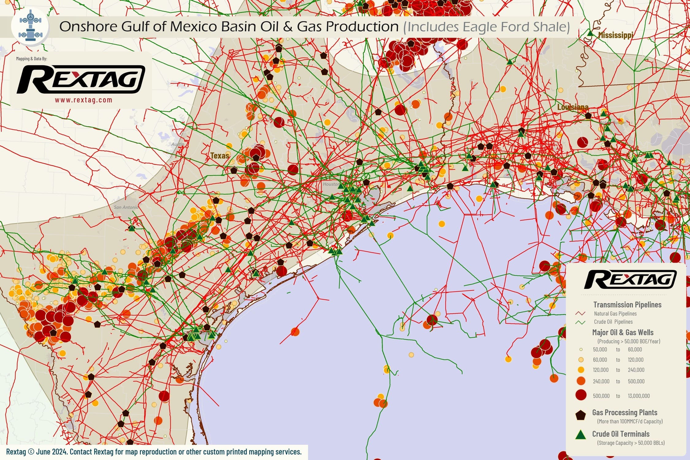
The Eagle Ford Shale is a significant hydrocarbon-producing geological formation that extends across approximately 26 counties in Texas. It stretches from the Mexican border near Laredo and Eagle Pass and continues northeast through counties east of Temple and Waco. The average lateral length of wells in the Eagle Ford Shale in Onshore Texas is approximately 7,500 feet. Additionally, some specific drilling operations in the area have reported a range of lateral lengths from 4,500 feet to 9,000 feet, with the average being around 5,500 feet. The daily production levels have been substantial, with oil production stabilizing at around 1,3 million barrels per day and 2,6 million BOE per day as of June 2023.

upstream oil and gas
Production Summaries
Monthly Production
Presented Data in the chart below is delayed - LOGIN FOR UPTODATE
Production by Operator
Production by Formation
Production by County
Top 10 wells
API Operator Trailing 12 Months BOE Total BOE Total Gas (MCF) Total Oil (BBL)
42-289-32180-0000 Comstock Oil & Gas, LP 1,309,255.83 1,309,255.83 7,855,535.00 0.00
42-289-32181-0000 Comstock Oil & Gas, LP 1,153,877.67 1,153,877.67 6,923,266.00 0.00
42-395-32063-0000 Comstock Oil & Gas, LP 1,276,563.50 2,657,314.33 15,943,340.00 91.00
42-395-32076-0000 Aethon Energy Operating, LLC 1,147,698.50 1,894,568.83 11,367,395.00 3.00
42-395-32078-0000 Aethon Energy Operating, LLC 1,267,675.33 1,627,822.33 9,766,934.00 0.00
42-395-32079-0000 Comstock Oil & Gas, LP 1,157,555.50 1,369,932.50 8,219,595.00 0.00
42-479-44791-0000 EOG Resources, Inc. 937,111.83 999,345.33 5,996,072.00 0.00
42-479-44838-0000 Ageron Energy, LLC 986,378.00 1,057,043.00 6,342,258.00 0.00
Completion Summaries
Avg Depths

Wells Depth

Min
0
Max
30,000
Avg
7,282

Wells Vertical Depth

Min
0
Max
30,000
Avg
2,225

Wells Lateral Length

Min
0
Max
22,438
Avg
1,710

Wells Measured Depth

Min
0
Max
43,801
Avg
3,403
Well Counts by Categories

Wells By Formation

Formation
Well Count
Eagle Ford
11,162
Eagle Ford - 1
10,781
Eagle Ford - 2
7,283
Olmos
6,987
Austin Chalk - 3
5,622
Wilcox
4,593
Lobo Cons
3,275
Eagle Ford Shale
3,168
Cv - Bossier Cons
2,151
Cotton Valley Cons
1,940

Wells By Status

Status
Well Count
Inactive, P/A
236,205
Active
74,307
Shut-in
37,800
Cancelled
29,852
Unknown
29,737
Permitted
3,260
Orphan
162
Drilling
75

Wells By Trajectory

Trajectory
Well Count
Vertical
261,017
Unknown
93,294
Horizontal
45,359
Directional
11,986

Wells By Operator

Operator
Well Count
ExxonMobil
19,718
Hilcorp
10,062
EOG
6,408
Marathon Oil
4,991
Lewis
3,239
Javelin Energy Partners MGMT
2,229
Merit
2,048
INEOS USA O&G
1,837
Magnolia O&G
1,804
Diversified Production
1,612
Well Completions
Presented Data in the chart below is delayed - LOGIN FOR UPTODATE
Well Permits
Presented Data in the chart below is delayed - LOGIN FOR UPTODATE
Completion by Operators
Completion by County

Rextag Energy DataLink™ Comprehensive Energy Intelligence Energy DataLink provides the largest and most complete database on energy infrastructure assets in North America. The Energy DataLink database contains asset ownership, production records, processing capacities, physical locations, planned projects, acquisition records and much more.