Uinta-Piceance Basin - Upstream Oil & Gas

Description

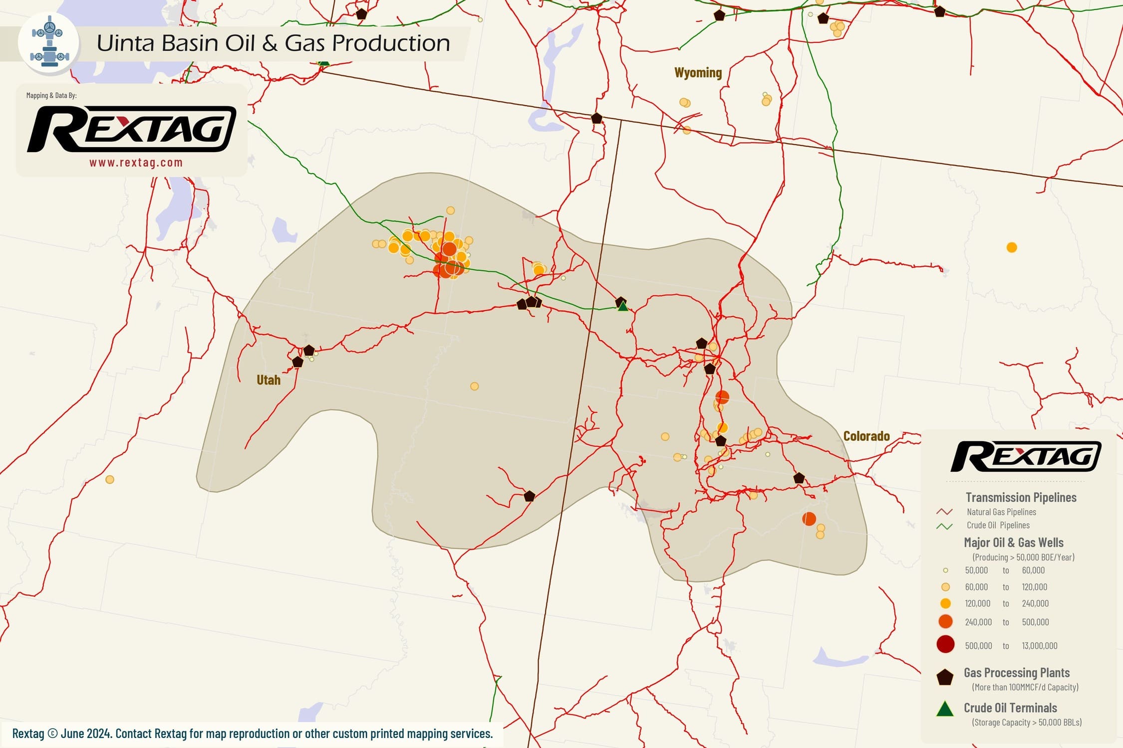
The Uinta-Piceance Basin, located across northeastern Utah and northwestern Colorado, is a region known for its abundant natural resources. Among this area's most significant geological formations are the Wasatch Formation, Green River Formation, Mancos Shale, Mesaverde Group, and Dakota Sandstone. Caerus Piceance leads with 59,258 MBOE per SQM, followed by EP Energy Corporation with 51,639 MBOE per SQM, TEP Rocky Mountain with 41,314 MBOE per SQM, Finley Resources at 33,406 MBOE per SQM, and XTO Energy rounding out the top five with 31,808 MBOE per SQM. At the start of 2023, daily production was 528,000 BOE per day, and at the end of 2023 already 595,000 BOE per day.

upstream oil and gas
Production Summaries
Monthly Production
Presented Data in the chart below is delayed - LOGIN FOR UPTODATE
Production by Operator
Production by Formation
Production by County
Top 10 wells
API Operator Trailing 12 Months BOE Total BOE Total Gas (MCF) Total Oil (BBL)
43-013-54085-0000 XCL Assetco, LLC 314,683.50 314,683.50 245,511.00 273,765.00
43-013-54145-0000 XCL Assetco, LLC 303,143.50 303,143.50 221,151.00 266,285.00
43-013-54147-0000 XCL Assetco, LLC 375,401.00 375,401.00 314,016.00 323,065.00
43-013-54150-0000 XCL Assetco, LLC 313,042.00 313,042.00 256,008.00 270,374.00
43-013-54244-0000 Javelin Energy Partners MGMT, LLC 352,705.33 358,787.00 783,732.00 228,165.00
43-013-54245-0000 Javelin Energy Partners MGMT, LLC 308,029.50 315,466.67 587,170.00 217,605.00
43-013-54264-0000 XCL Assetco, LLC 356,285.67 356,285.67 269,812.00 311,317.00
43-047-57103-0000 Middle Fork Energy Uintah, LLC 399,579.67 399,579.67 2,281,492.00 19,331.00
43-047-57212-0000 Anschutz Exploration Corporation 300,154.67 300,154.67 1,227,604.00 95,554.00
43-047-57359-0000 Middle Fork Energy Uintah, LLC 355,642.67 355,642.67 2,020,852.00 18,834.00
Completion Summaries
Avg Depths

Wells Depth

Min
0
Max
20,900
Avg
7,226

Wells Vertical Depth

Min
0
Max
20,797
Avg
6,780

Wells Lateral Length

Min
0
Max
13,635
Avg
1,100

Wells Measured Depth

Min
0
Max
24,865
Avg
7,824
Well Counts by Categories

Wells By Formation

Formation
Well Count
Williams Fork - Cameo
8,540
Green River
5,147
Williams Fork
4,789
Wasatch - Mesa Verde
3,971
Wasatch
2,544
Green River - Wasatch
1,630
Mesa Verde
1,334
Ferron Sandstone
1,086
Mancos B
783
Weber
611

Wells By Status

Status
Well Count
Inactive, P/A
30,916
Active
24,246
Shut-in
2,924
Permitted
1,369
Unknown
888
Cancelled
542
Drilling
251

Wells By Trajectory

Trajectory
Well Count
Directional
26,409
Vertical
23,726
Unknown
10,570
Horizontal
435

Wells By Operator

Operator
Well Count
Terra
8,843
Caerus
6,250
Caerus Uinta
3,057
Scout Energy
2,925
Berry
2,381
Laramie
2,159
Middle Fork Energy Uintah
1,740
Utah Gas Op
1,328
Greylock
1,244
Urban
916
Well Completions
Presented Data in the chart below is delayed - LOGIN FOR UPTODATE
Well Permits
Presented Data in the chart below is delayed - LOGIN FOR UPTODATE
Completion by Operators
Completion by County

Rextag Energy DataLink™ Comprehensive Energy Intelligence Energy DataLink provides the largest and most complete database on energy infrastructure assets in North America. The Energy DataLink database contains asset ownership, production records, processing capacities, physical locations, planned projects, acquisition records and much more.